
A punchier, sharper kind of cold is lining up: an Arctic Plunge that drops like a trapdoor, flips routines, and tests the nation’s grit—literally. It moves fast, hits hard, and leaves behind glittering pavements and frayed tempers.
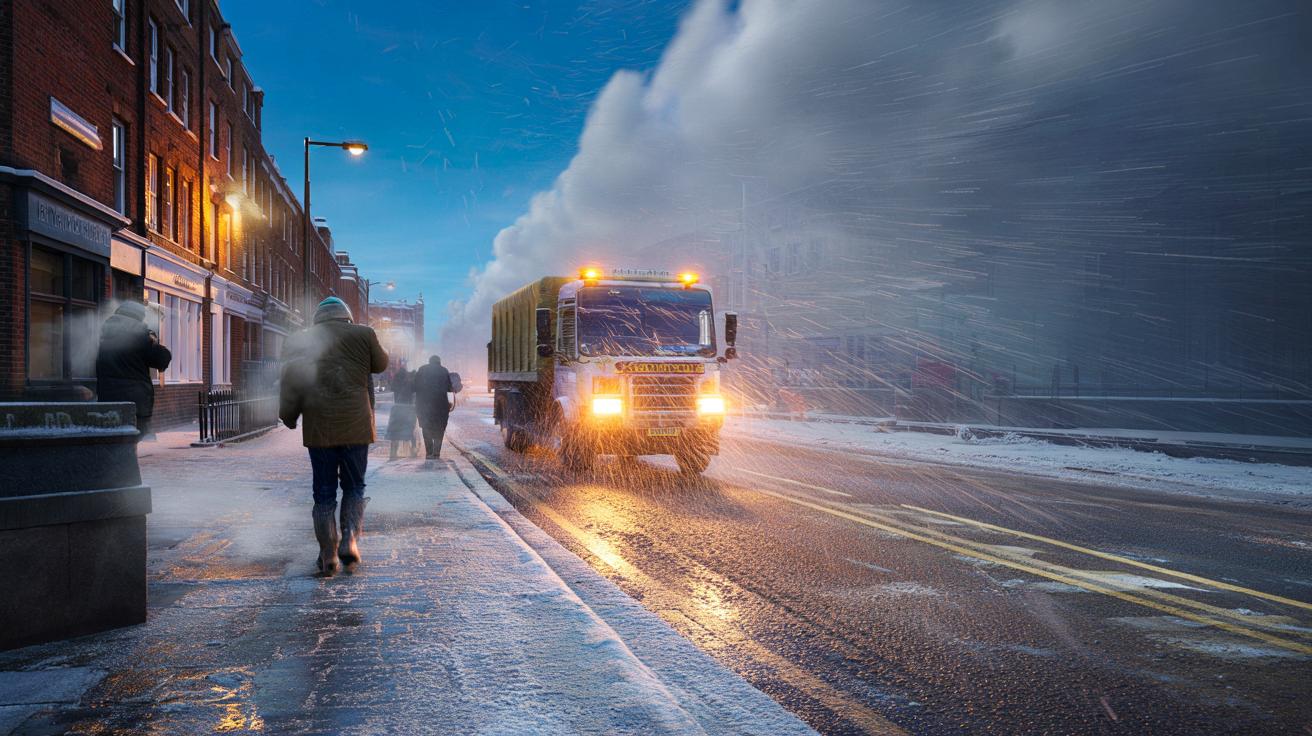
At first, it was only a feeling at the bus stop in Leeds—breath turning silver, a faint sting in the nostrils, the sort of cold that narrows your eyes. Then came the murmurs in corner shops and WhatsApp groups: “Have you seen the charts?” Gritters began to hum after midnight, headlights fogged by their own salt spray. A builder outside Elephant & Castle shrugged on a second fleece and laughed that winter had finally remembered London. *The air feels like it has edges.*
What this Arctic Plunge really means
You know the “Beast from the East”: a long, grinding easterly with steady snow and days of minus-something. This is different. An Arctic Plunge is a short, sharp delivery from the north and northwest—cold air cascading over Britain like a pail of icy water. It can turn rain to snow on a single street and spare the next one along. Think squally, not stately; stings of snow, gaps of sun, and wind that whistles under doors.
On days like these, the Midlands can sit in sunshine at 11 a.m. and then lose visibility under a booming snow shower at 11:12. You’ll see curtains of white marching off the Irish Sea, hammering Liverpool and Preston, while the Pennines act like a snow factory for Yorkshire. In Scotland’s north and west, wind chill can bite to -10C on exposed hills, even when thermometers read a gentler -2C. The change is the drama: a drop of 8–10C in 24 hours is fair game.
It happens when the jet stream buckles and lets Arctic air spill south—sometimes around a Greenland block, sometimes off a lobe of disturbed polar vortex. The airmass is maritime polar or straight Arctic, drier overhead but loaded with potential over warmer seas. Those seas feed the showers. They roll ashore, pop, and fade, leaving a dusting on one cul-de-sac and next to nothing on another. Forecasts can nail the trend and still miss the driveway.
How to ride it, not suffer it
Plan in small, repeatable moves. Layer thin, breathable clothes, then add a windproof shell. Keep a “cold snap kit” by the door—hat, gloves, compact umbrella, head torch, and a power bank at least half-charged. If you commute, leave 20 minutes earlier and aim between shower lines on radar. Set your heating to a steady, modest baseline and crack open internal doors so warmth reaches the cold corners.
People forget the basics when the weather flips. Windscreen fluid freezes if it’s summer mix; top up with winter-grade now. Trainers on black ice are an A&E queue waiting to happen; wear tread. Don’t breathe with your mouth in the wind if you can help it—your throat will tell you off later. Let’s be honest: nobody actually does that every day. Pack snacks and water if you drive, then stop trying to be a hero with bald tyres.
Watch the sky, not just the app. When showers build cauliflower tops and lines stack against the wind, you’ve got 20–30 minutes to re-time your school run or nip to the shops.
“We treat the same road three times on a showery night,” a gritter supervisor in Northumberland told me. “It’ll be fine, then slippy, then fine again. People think we’ve missed it. We haven’t. The weather just keeps moving.”
- Check live radar before leaving, then again at the door.
- Keep phone, torch, and a foil blanket in the car boot.
- Use low gears downhill; black ice hides in shade after lunch.
- Protect outside taps; a simple cover or old towel can save a burst pipe.
- Ask a neighbour if they need bread or medicine—one trip beats three.
The bigger picture, and why it matters
Our winters are shape-shifting. Warmer on average, yet still capable of knife-edged outbreaks when the atmosphere lines up. That’s the contradiction people feel: roses budding in December, then sleet in the kitchen sink by late January. The Arctic Plunge borrows drama from the jet stream and the North Atlantic, then leaves as quickly as it arrived, sometimes with a low hush of snow like the end credits of a film.
It also pokes holes in memory. The Beast from the East looms because it lingered and shut down whole motorways, but plenty of households remember a finer pain: school runs snatched between snow showers, buses vanishing, pavements glittering under street lamps. A plunge exposes the gaps—drains, grit bins, overconfident drivers—and makes neighbourhoods visible again. We’ve all had that moment when plans scatter like pigeons because the sky decides to change the script.
The lesson isn’t fear; it’s choreography. Small routines, checked routes, warm rooms, and kinder timing. Britain copes best not by brute force, but by reading the weather as it unfolds and moving with it. That’s old wisdom dressed in a high-res app. Share it, update it, and let it breathe. The cold will move on. Your habits can stay.
| Key point | Detail | Interest for the reader |
|---|---|---|
| Arctic Plunge vs “Beast” | Short, showery bursts from the north/northwest vs prolonged easterly flow | Explains why your street gets snow while the next one stays dry |
| Jet stream pattern | Buckled jet, Greenland block, maritime polar air crossing warmer seas | Helps decode radar maps and time errands between showers |
| Everyday impact | Rapid temperature drops, wind chill, micro-scale travel disruption | Turns vague alerts into concrete, life-saving micro-choices |
FAQ :
- What exactly is an “Arctic Plunge”?A swift southward spill of very cold air from the Arctic into the UK, often on a north to northwest wind. It brings hit-and-miss snow showers, sharp wind chill, and short weather windows.
- How is it different from the “Beast from the East”?The Beast is a sustained easterly from Siberia with widespread, persistent snow risk. A plunge is shorter, showery, and more localised—intense for hours to a couple of days rather than a full week.
- Will everyone see snow?No. Coastal exposure, elevation, and wind direction decide it. Western and northern coasts often see the first showers; the east can cash in if lines rotate and align with the North Sea.
- How long could this one last?Typically 24–72 hours of the sharpest cold, with lingering frost. If the jet realigns or a low darts through, conditions can flip back to milder within a day.
- What should I do today?Top up winter screenwash, charge a power bank, check local grit bins, and eyeball live radar before commuting. Keep layers ready by the door and pick travel windows between shower lines.


Fantastic explainer—finally a clear difference between the Beast and an Arctic Plunge. The “squally not stately” line nails it. Quick Q: for Leeds/West Yorks tomorrow, do you expect organised streamer lines or more hit‑and‑miss pulses given wind shear and sea temps? I’m definitley watching the radar.