
Forty‑five UK towns are now flagged for a ‘significant’ flooding risk this weekend, with agencies urging people to act while there’s still time.
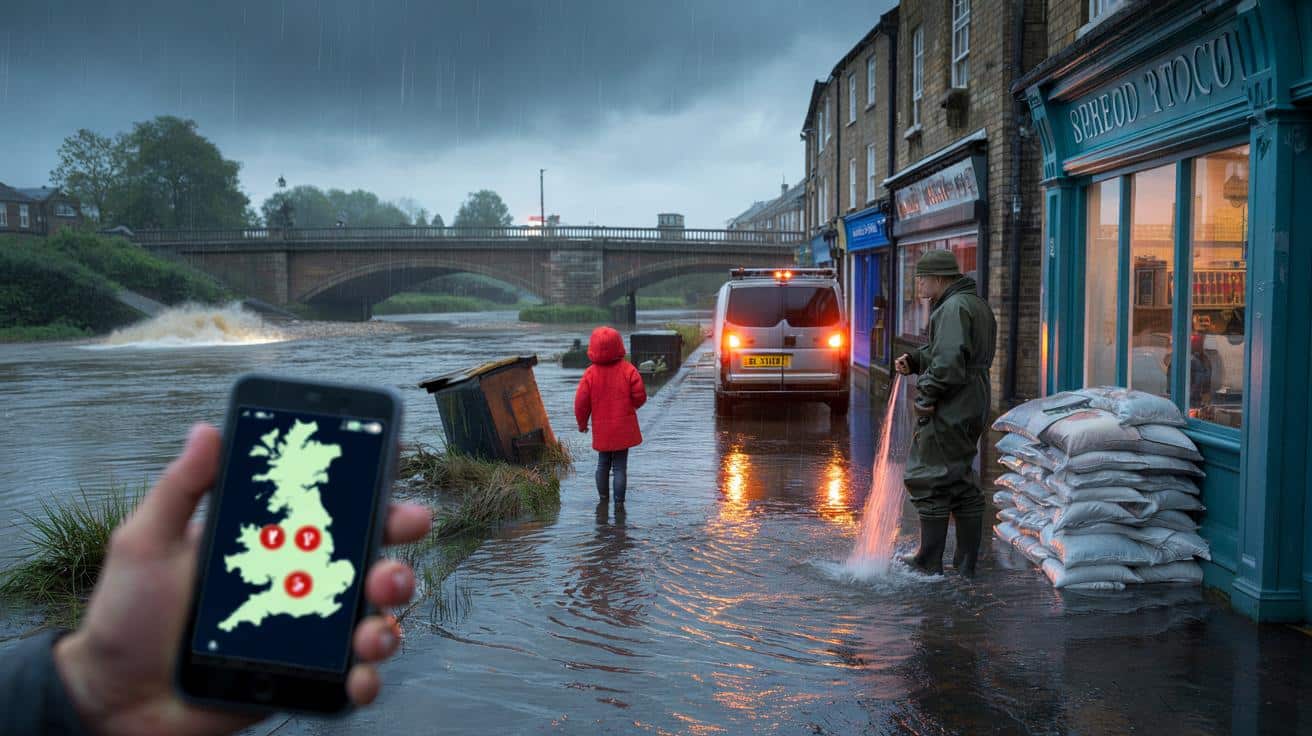
The sky turned the colour of wet slate just after dawn, and the river started moving like a living thing. Dog walkers slowed at the taped‑off towpath, peering over the railing as driftwood slapped the arches. Somewhere upstream, you could hear the groan of a bin rolling in the current. Vans idled with their hazards on, and a shopkeeper in waders hosed mud off yesterday’s doorstep, as if repetition alone could keep history at bay. *The river was talking louder than usual.* My phone buzzed with new alerts and a map that kept spreading like spilled ink. A kid in a red coat asked his dad why the path had disappeared. The answer hung in the air. The map turned red overnight.
Where the water is likely to hit hardest
Forecasters and flood agencies say a chain of slow‑moving rainbands will sit over already sodden catchments, pushing rivers and drains toward their limits. When the ground can’t drink any more, water moves sideways and fast, collecting in the lowest places. Add high tides into some estuaries and you get a squeeze effect that leaves the water nowhere to go. This isn’t about single downpours. It’s about a week of weather stacking up on one fragile weekend.
At street level, you can feel the jitter. In Tewkesbury last winter, I watched a baker line up sandbags like loaves, one after another, while a neighbour zipped family albums into a freezer bag. You hear the same stories from Bewdley to York: block the air bricks, lift the sofa, move the car to the hill. Trains crawl, then stop. School WhatsApp groups light up. A taxi driver in Shrewsbury told me he keeps two routes in his head for every pickup now, because the bridge he used yesterday might be under water by teatime. Small pivots, big stakes.
When agencies talk about a **significant flood risk**, they don’t mean every door will take water. They mean that, across these towns, the chance of meaningful disruption is high enough to plan for. That could be ankle‑deep water through ground floors, closed A‑roads, cut power, or sewage backing up where drains meet swollen rivers. The risk spans surface water from intense showers and river flooding where upstream flow keeps rising even after the rain stops. Coastal influence nudges some estuaries further. It’s the combination that bites, often at night, when response is slower and messages are missed.
How to use the next 12 hours
Start with the simple, boring wins. Sign up for property alerts and **check live flood warnings** from your nation’s agency. Photograph each room at waist height for your insurer. Lift rugs, wires, and anything you can’t easily replace. Move the car to higher ground, not just the kerb. Pack a small grab bag: meds, chargers, a torch, dry socks, pet food, spare keys. Put contact numbers on paper. If you have flood boards or door barriers, fit them in daylight now, not by head‑torch later.
We’ve all had that moment when the forecast feels abstract and tomorrow’s problem. That’s how people get caught. Don’t stack sandbags straight onto bare thresholds; lay plastic sheeting first and build them like bricks, offset and flat. Know where your stopcock is and how to flip the electrics off. Keep children and pets away from fast water. Let’s be honest: nobody really does that every day. Do it today, and you’ll forgive your future self.
There’s also the question on everyone’s lips: where is the threat concentrated right now? Agencies have highlighted towns across the UK where impact is most likely this weekend. The picture will evolve through the day, so treat this as a guide and refresh official pages for your postcode before you travel or settle in.
“The water rarely looks dangerous until it’s already in your hallway. Five minutes of prep now saves five days of recovery next week,” a local flood warden told me on the phone.
- York
- Leeds
- Hebden Bridge
- Mytholmroyd
- Todmorden
- Doncaster
- Sheffield
- Rotherham
- Goole
- Selby
- Malton
- Pickering
- Carlisle
- Appleby‑in‑Westmorland
- Kendal
- Keswick
- Cockermouth
- Lancaster
- Garstang
- Shrewsbury
- Ironbridge
- Bewdley
- Worcester
- Upton‑upon‑Severn
- Tewkesbury
- Gloucester
- Hereford
- Tenbury Wells
- Oxford
- Abingdon
- Wallingford
- Reading
- Perth
- Brechin
- Dumfries
- Hawick
- Elgin
- Bangor‑on‑Dee
- St Asaph
- Ruthin
- Newport
- Chepstow
- Newry
- Coleraine
- Enniskillen
What this weekend could change
Floods are never only about water. They redraw how a place breathes for months: which pub opens, where the bus turns, who’s still on the high street by spring. Communities get good at the dance — the WhatsApp lists, the kettle on a table above the skirting board — but it asks a lot, again and again. Insurance blunts the shock but not the ache of lifting your life into boxes before bed. Some will come out of this weekend with a close call and a story. Others will be scrubbing silt out of drawers. Share this with the person who always shrugs at the forecast, and check in on the neighbour who won’t ask for help. Water respects no postcode. Prepared people do.
| Key point | Detail | Interest for the reader |
|---|---|---|
| Who is most at risk | Forty‑five towns flagged by flood agencies for likely disruption across rivers, drains and some coastal pinch points | See if your area is named and what that could mean in practical terms this weekend |
| What to do today | Move cars and valuables, fit barriers in daylight, pack a grab bag, photograph rooms for claims, follow live warnings | Small actions now reduce damage, stress and costs if water rises overnight |
| How to stay safe | Keep away from fast water; cut power if water enters; **never drive through floodwater** even if it looks shallow | Prevents accidents, car write‑offs and the most common flood‑related injuries |
FAQ :
- What does “significant” flood risk actually mean?It signals a higher‑than‑usual chance of impacts like flooded roads, property inundation, and service disruption across the highlighted areas, not a guarantee that every street will flood.
- How can I tell if my home is likely to be affected?Check your postcode on your nation’s flood‑warning service, look at river level gauges nearby, and note whether your street sits lower than surrounding ground or close to a watercourse.
- Should I get sandbags or purpose‑made flood boards?Boards and door barriers seal better and faster; if using sandbags, lay plastic sheeting first and stack them tight and offset. One layer badly placed won’t hold back a push of water.
- Is it safe to drive through standing water?No. Even 30cm can float a car, and you can’t see what’s beneath. Turn around, choose a higher route, or delay your trip until levels drop.
- Where can I get reliable updates?Use official flood‑warning pages for England, Scotland, Wales and Northern Ireland, local council feeds, and trusted travel alerts. Refresh often as conditions shift through the day.


Is “significant” just headline fluff or are we talking ankle‑deep in living rooms? Feels vague.
Appreciate the step‑by‑step. Photographed rooms and moved the car uphill; didn’t think about putting contact numbers on paper—smart.