
Beneath a calm Peak District reservoir lies a village that resurfaces in dry spells — touching raw memory, drawing day-trippers, and asking awkward questions about water, weather and what we choose to forget.
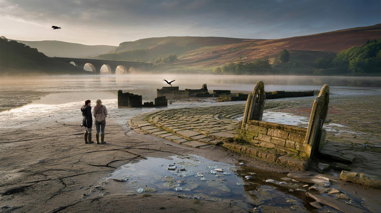
A thin skin of mist hangs above the basin and, where the shore should be smooth, a dark grid of stones pokes through like a half-remembered dream. Two walkers stand in wellies, pointing: a lintel here, a doorstep there, a lane that stops abruptly at the waterline.
The air carries that wet-earth smell you only catch after a long dry spell. A lapwing snaps past, and the crunch underfoot turns from grit to glassy pottery shards. For a second, the modern reservoir hushes, as if listening to an older rhythm. Stone by stone, a street returns.
And then it surfaces.
The village beneath the reservoir
There really is a village down there — two, if you ask locals. Derwent and Ashopton were flooded to form Ladybower Reservoir in the 1940s, their people rehoused, their buildings dismantled or left to the water. When levels drop, the bones show through: house foundations, field walls, a curved street where tyres grind to a careful halt.
Look back at old photos and you’ll find the church spire that once stood above the water, blown down after crowds gathered in dangerous numbers to see it. In the summers of 1976, 1995, 2018 and again in 2022, drought cracked the surface and the past walked out. Kids clambered over lintels. Grandparents stood quietly, trying to match a memory to a pile of stone.
This apparition isn’t magic. It’s hydrology, heat and human need, all tugging at a shared resource. Ladybower feeds taps across the Midlands; demand swells; the seasons skew. When inflow falters and outflow continues, the bowl lowers like a held breath. **That’s when the grid of a vanished village presses through the mud and demands your attention.**
How much is lost — and how often it returns
On good days, the shoreline is tidy and the water level high, and you’d never guess at what lies beneath. On certain dry weeks, though, the exposed banks turn into an improvised archaeological map. A doorway here, a tumbled wall there, a bridge footing making its shy, stubborn cameo.
2018 brought a rash of headlines as stonework surfaced near Ashopton Viaduct, drawing long lines of people to the lay-bys. In 2022, heat browned the moors and Ladybower sank again, revealing cobbles that had last seen daylight when ration books were a thing. Numbers aren’t precise, but anyone who lives here will tell you: when the high slopes look tired and the dams aren’t roaring, eyes turn to the shallows.
The timing isn’t random. Reservoir managers balance supply, keep ecological flows downstream, and watch the sky for rain that may or may not arrive. Longer dry spells make the odds of a reveal more likely, especially in late summer or early autumn. **In a warming, wobblier climate, these ghostly appearances feel less like rare curiosities and more like a pulse check.**
Why it was drowned, and what remains to see
Derwent and Ashopton were sacrificed to serve a growing region. Planning began in the interwar years; construction accelerated as Britain stared down modernity and the aftershocks of conflict. It wasn’t neat, and not everyone agreed, but water wins arguments in the end.
Bulldozers chewed through cottages; the church lost its spire; stones were carted, reused, or left. A historic packhorse bridge was lifted, piece by piece, and rebuilt upstream. What stayed behind slipped into a new, silty logic — fences horizontal, hearths blanketed, hedges turning to lines on a map that only occasionally show.
When they do, it’s a set of fragments, not a pack-your-picnic postcard of a neatly preserved main street. You get thresholds and outlines. You get the ghost of a well. **What you really get is a moment — when a place insists it still has a say.**
How to catch the village when it shows
Watch the weather, not just the calendar. Long, dry spells in late summer are your best bet, and the week after a heatwave can be golden. Early mornings on still days reveal the most detail, before footprints, rain or busy weekends scrub the outlines.
Keep a casual eye on Severn Trent updates and local ranger posts, but also look for the on-the-ground signs: quiet dam spillways, shoreline widening, silt cracking like old paint. Let’s be honest: nobody checks reservoir datasets every morning. A quick glance at local Facebook groups or Peak District community boards goes a long way.
Walk from Heatherdene car park towards Ashopton Viaduct and scan the bays, or head up the eastern shore for a broader view. Take light boots you don’t mind muddying, and a flask so you don’t rush. It feels both wrong and right at the same time.
Common mistakes to dodge (and what to do instead)
Don’t stride onto the pale, soft stuff. That silty mud looks firm until it doesn’t, and rescue crews would rather not practice on a Tuesday afternoon. Stick to the darker, compacted ground and established paths, and treat every bank like it’s booby-trapped by physics.
Resist the urge to pocket “just one” shard of tile. It’s tempting, I know, but the story belongs in place. Photos are kinder. Drone flyers: keep your kit legal and considerate. The valley carries sound; wildlife spooks; nobody wants a buzzing soundtrack to their quiet look back in time.
You will meet people standing still. Give them space. They might be connecting pin-sharp childhood details to a foundation stone they last saw through a car window, decades ago.
“I never cried when we moved,” said Ian H., a retired engineer from Sheffield, looking at a doorway reappearing under a hazy noon. “Didn’t expect to now, either. Then I saw the step where my gran kept a plant pot, and that was that.”
- Best daylight: early morning or the last hour before dusk.
- Safer footing: gravelly margins and established tracks.
- Good viewpoints: Ashopton Viaduct, eastern shore paths, above the Derwent Dam towers.
- Small kit list: lightweight boots, windproof, phone power bank, a bin bag for litter you didn’t make.
What it says about us
We’ve all had that moment when a place folds time and your chest goes thin. Here, it’s the jolt of seeing a village refuse to stay tidily buried, telling you that utility and memory share the same postcode. You come for a curiosity. You leave with a knot you can’t quite name.
These sudden reveals aren’t museum-perfect. They’re messy, fragile and fleeting. They remind you that progress costs, that landscapes are edited, and that the edits sometimes bleed through. Share the tip-offs, swap vantage points, tell the stories you’ve heard and the ones you carry close. Maybe next time the water falls, you’ll see a single step and recognise the weight it once held.
| Key point | Detail | Interest for the reader |
|---|---|---|
| Where the village is | Derwent and Ashopton lie beneath Ladybower Reservoir in the Peak District | Pinpoints the spot for a real-world visit or virtual deep dive |
| When it appears | After prolonged dry spells, often late summer or early autumn | Sets expectations so a trip isn’t a gamble |
| How to see it well | Go early, stick to firm paths, focus on Ashopton Viaduct bays and eastern shore | Maximises your chances and keeps you safe and respectful |
FAQ :
- Is there really a “lost” village under Ladybower?Yes — the former villages of Derwent and Ashopton were flooded in the 1940s to create the reservoir.
- How often do the ruins appear?Only during notably low water periods, typically after extended dry weather; some years they don’t show at all.
- Is it safe to walk out to the remains?Stick to established paths and firm ground; soft silt can be hazardous and fast-sinking.
- Can I collect pieces as souvenirs?Best practice is to leave everything in place; take photos and leave the site as you found it.
- What’s the best viewpoint?Ashopton Viaduct, the eastern shoreline paths, and high ground near Derwent Dam offer broad, revealing angles.


So it’s basically Britain’s peekaboo Atlantis, resurfacing whenever the Midlands gets parched? Spooky and kinda brilliant.